|
 Location Location
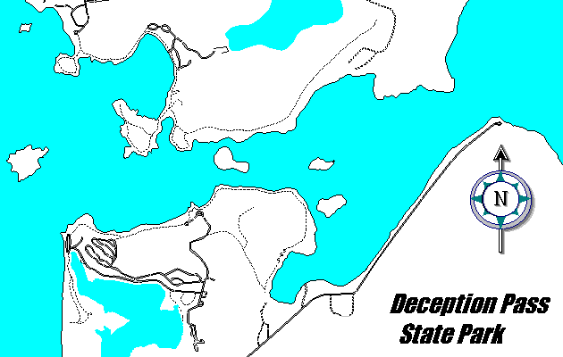
Deception Pass State Park is located nine miles north
of Oak Harbor, nine miles south of Anacortes on Fidalgo and Whidbey Islands on State
Highway 20, in Island and Skagit Counties.
Acreage
4,128.29 acres with 77,000 feet of saltwater shoreline and 28,200 feet of freshwater
shoreline on Cranberry Pass, and Campbell Lakes, and 5,700 feet of freshwater shoreline on
Heart Lake. Includes 568 acres at Hoypus Hill and 586 acres at Dugualla.
Acquired
This park was acquired in 16 parcels; the first in 1925 and the last in 1992, for a
total cost of $7,497,628.71.
Historical Background
The first record of discovery of the area by the Spaniards is dated 1791. The 1792
Captain George Vancouver expedition named Deception Pass. Further exploration of this area
was conducted by the Wilkes Expedition in 1841. By an act of Congress in 1925, a land
grant gave the State of Washington 1,744.37 acres for public park purposes. In 1933, the
Civilian Conservation Corps (C.C.C.) started development of the park.
Facilities
Day Use Areas - 8 (West Beach, North Beach, Cranberry Lake, Cornet Bay, Rosario, Bowman
Bay, Heart Lake and Pass Lake), 306 picnic sites, 6 kitchens, 5 picnic shelters, 11
comfort stations, 6 vault toilets and parking for 1,194 vehicles.
Camp Area - 246 standard sites and 5 primitive bike/walk-in campsites, 9 comfort
stations (6 main camp, 1 Bowman Bay, 2 ELC), 65 person overnight group camp facility at N.
Beach with 2 Adirondack shelters, 1 kitchen and vault toilet. Opened 1988.
Swimming Area - 300 feet of unguarded beach and large concession/bathhouse/comfort
station building.
Marine Area - 1 fishing dock, 2 docks, 12 moorage floats, 11 mooring buoys, 3
freshwater and 5 saltwater boat launch ramps, 12 grounding floats, 1 swim float, 5 fishing
floats, 3 multiple sites on Skagit Island, 5 primitive campsites on Hope Island, and 1
boat pumpout station at Cornet Bay.
Other - l Environmental Learning Center, 4 residences, 1 mobile home, 1 duplex
residence, 2 shops, 4 garages, 2 barns, 1 concession/bathhouse, 1 CCC Interpretive Center
at Bowman Bay (staffed by volunteers), an amphitheater, 35 miles of hiking trails, 1�
miles of interpretive trail, an underwater park at Rosario Beach, and Headquarters for the
Marine Construction and Maintenance crew at Cornet Bay.
Activities
Camping, group camping, picnicking, swimming, scuba diving, boating, fishing, hiking,
interpretation, and ELC camping.
Of Special Interest
Heart Lake Natural Forest, Hoypus Point Natural Forest, CCC Interpretive Center at
Bowman Bay.
Back
to Island Region Map |